-40%
Civil War Blockade Map Relay House Winas Steam Gun Weaver 1861 Harper's Weekly
$ 21.12
- Description
- Size Guide
Description
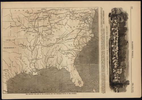
Map Showing the Line of the Blockade, and the Strategic Routes in the Interior.(American Civil War, Blockade War Map, Indian Territory, Winas Steam Gun, Harper's Weekly, A Journal of Civilization, Weaver)
Issued 1861, New York, by Harper & Brothers.
Original antique offset printed image produced during the American Civil War. An actual printed leaf taken from this scarce old periodical, published at the date listed. This early Civil War map depicts the United States from Florida to Pennsylvania and as far west as modern day Texas and Oklahoma, here named "Indian Territory". The newspaper leaf includes other interesting captioned images including:
Camp of United States Volunteers at the Relay House.
Winans Steam Gun, Captured by Colonel Jones on the Way to Harper's Ferry.
The Relay House, Washington Junction, Now Occupied by the Federal Volunteers.
The Washington Junction Viaduct, Commanded by the Winans Gun and Federal Artillery.
A nice looking example of printed, ephemeral history with a pleasing age patina. Any minor age flaws are easy to forgive and add to its antique aesthetic. Text and images on reverse as issued. An elusive image, worthy of display. Provided photos show the front and back of the item, not two discrete prints.
Mounted and framed, this piece would make an excellent decoration for your home, restaurant, office, classroom, or any other space where people appreciate the vintage aesthetic of antique printed history.
Measures 16"H x 11"W
[M20]
Civil War Blockade Map Relay House Winas Steam Gun Weaver 1861 Harper's Weekly
Map Showing the Line of the Blockade, and the Strategic Routes in the Interior.
(American Civil War, Blockade War Map, Indian Territory, Winas Steam Gun, Harper's Weekly, A Journal of Civilization, Weaver)
Issued 1861, New York, by Harper & Brothers.
Original antique offset printed image produced during the American Civil War. An actual printed leaf taken from this scarce old periodical, published at the date listed. This early Civil War map depicts the United States from Florida to Pennsylvania and as far west as modern day Texas and Oklahoma, here named "Indian Territory". The newspaper leaf includes other interesting captioned images including:
Camp of United States Volunteers at the Relay House.
Winans Steam Gun, Captured by Colonel Jones on the Way to Harper's Ferry.
The Relay House, Washington Junction, Now Occupied by the Federal Volunteers.
The Washington Junction Viaduct, Commanded by the Winans Gun and Federal Artillery.
A nice looking example of printed, ephemeral history with a pleasing age patina. Any minor age flaws are easy to forgive and add to its antique aesthetic. Text and images on reverse as issued. An elusive image, worthy of display. Provided photos show the front and back of the item, not two discrete prints.
Mounted and framed, this piece would make an excellent decoration for your home, restaurant, office, classroom, or any other space where people appreciate the vintage aesthetic of antique printed history.
Measures 16"H x 11"W
[M20]


